


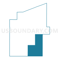
Voting District 0137600000001, Baraga County, Michigan
About
Outline

Summary
| Unique Area Identifier | 595876 |
| Name | Voting District 0137600000001 |
| County | Baraga County |
| State | Michigan |
| Area (square miles) | 159.33 |
| Land Area (square miles) | 151.11 |
| Water Area (square miles) | 8.22 |
| % of Land Area | 94.84 |
| % of Water Area | 5.16 |
| Latitude of the Internal Point | 46.48156350 |
| Longtitude of the Internal Point | -88.24340260 |
Maps

Graphs
Select a template below for downloading or customizing gragh for Voting District 0137600000001, Baraga County, Michigan


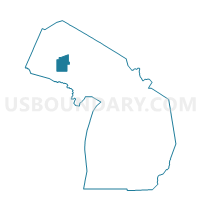
Neighbors
Neighoring Voting District (by Name) Neighboring Voting District on the Map
- Voting District 0131860000001, Baraga County, MI
- Voting District 0134556000001, Baraga County, MI
- Voting District 0711915000001, Iron County, MI
- Voting District 0713758000001, Iron County, MI
- Voting District 1035354000001, Marquette County, MI
- Voting District 1036800000001, Marquette County, MI
Top 10 Neighboring County Subdivision (by Population) Neighboring County Subdivision on the Map
- L'Anse township, Baraga County, MI (3,843)
- Crystal Falls township, Iron County, MI (1,743)
- Republic township, Marquette County, MI (1,060)
- Covington township, Baraga County, MI (476)
- Michigamme township, Marquette County, MI (349)
- Hematite township, Iron County, MI (338)
- Spurr township, Baraga County, MI (276)
Top 10 Neighboring Place (by Population) Neighboring Place on the Map
Top 10 Neighboring Unified School District (by Population) Neighboring Unified School District on the Map
- N.I.C.E. Community Schools, MI (7,030)
- L'Anse Area Schools, MI (4,992)
- Forest Park School District, MI (4,447)
- Republic-Michigamme Schools, MI (1,508)
Top 10 Neighboring State Legislative District Lower Chamber (by Population) Neighboring State Legislative District Lower Chamber on the Map
Top 10 Neighboring State Legislative District Upper Chamber (by Population) Neighboring State Legislative District Upper Chamber on the Map
Top 10 Neighboring 111th Congressional District (by Population) Neighboring 111th Congressional District on the Map
Top 10 Neighboring Census Tract (by Population) Neighboring Census Tract on the Map
- Census Tract 2, Baraga County, MI (4,558)
- Census Tract 1, Baraga County, MI (4,302)
- Census Tract 1, Iron County, MI (2,358)
- Census Tract 23, Marquette County, MI (2,308)
Top 10 Neighboring 5-Digit ZIP Code Tabulation Area (by Population) Neighboring 5-Digit ZIP Code Tabulation Area on the Map
- 49920, MI (4,273)
- 49946, MI (4,040)
- 49814, MI (1,429)
- 49879, MI (1,038)
- 49861, MI (616)
- 49919, MI (242)
- 49903, MI (133)